The UN General Assembly has endorsed a non-binding resolution calling for a gradual phase-out of the Mercator projection in favour of the Equal Earth projection, which more accurately reflects the relative sizes of the continents. The document was endorsed by 164 countries; the US voted against it, whilst a further six states abstained. The resolution does not impose a mandatory transition on states or organisations.
Briefly about the main points
- The UN resolution recommends gradually phasing out the Mercator projection.
- The US voted against the resolution, whilst six countries abstained.
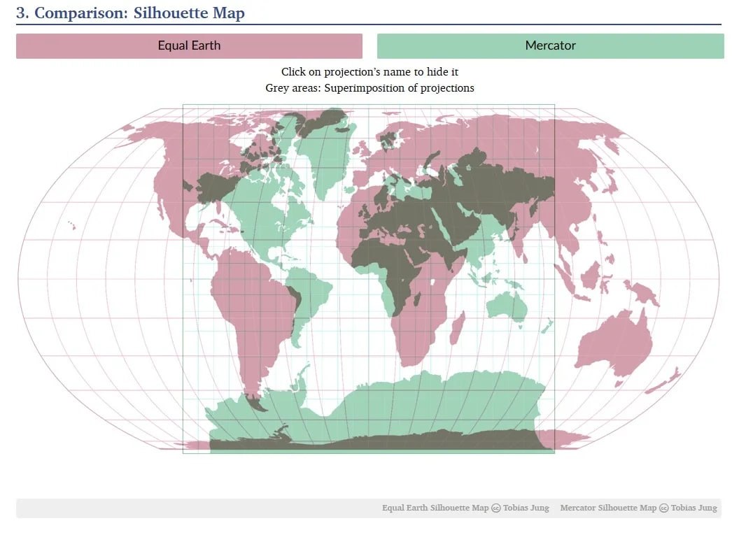
- The Mercator projection visually reduces the size of the equatorial regions and enlarges those at high latitudes.
- The #CorrectTheMap campaign, on behalf of the African Union, was led by Togo.
- In Lomé, there are plans to discuss the practical implementation of the recommendations.
The resolution does not lay down a single mandatory standard
The adopted document calls for the formal abandonment of the traditional map, which has been the global standard for almost five centuries. A US representative described the resolution as «superfluous».
General Assembly resolutions are not binding. Consequently, countries, educational institutions, technology companies and other organisations are not obliged to switch to Equal Earth immediately or to stop using the Mercator projection. At the same time, the widespread use of the old projection in education, technology and public administration means that the decision could have an impact on teaching materials and digital products.
Why does the Mercator projection distort our perception of area?
Flemish cartographer Gerard Mercator He devised his projection in 1569 for maritime navigation. Its distinctive feature is that the areas near the equator appear significantly smaller on the map than they are in reality, whilst regions at high latitudes appear larger.
The most striking example is Africa: on a Mercator map, it appears to be roughly the same size as Greenland, although in reality the continent is 14 times larger than the Danish territory. The Equal Earth projection was developed in 2018 by an international team of cartographers as an alternative that preserves the ratios of areas more accurately.
Historians, geographers and campaigners have for years criticised Mercator for the fact that such a visual representation can reinforce misconceptions about the size of countries in the Global South. Supporters of the change describe it as a matter of accuracy in cartographic and educational representation.
Togo put forward the initiative on behalf of the African Union
Togo led the campaign for the resolution on behalf of the African Union. The African Union endorsed the #CorrectTheMap campaign in August 2025, after which it tasked Togo with promoting it at the UN.
Minister for Foreign Affairs of Togo Robert Dussay Before the vote, he described the debate as scientific, citing evidence of area distortion in the Mercator projection. Togo stated that these disproportionate cartographic representations had had a lasting cognitive, educational, cultural, geopolitical and socio-economic impact.
France supported the resolution and announced its intention to use the Eckert IV projection. It is similar to the Equal Earth projection in that it reflects actual areas.
Preparations are under way in Lomé for a discussion on the implementation of the recommendations
The Togolese Government plans to hold an event in the capital, Lomé, in the first quarter of next year. The following are expected to take part: UNESCO, the African Union and technology brands, including Google Maps.
The participants at the meeting are to discuss ways of implementing the resolution. As it is of a non-binding nature, the pace and specific methods of transition will be determined by individual countries and institutions.